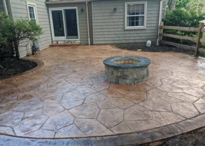
In the fast-paced world of construction planning, precision and foresight are crucial for project success. Traditional 2D blueprints and site surveys, while effective, often fall short in capturing the full scope of a project’s environment.
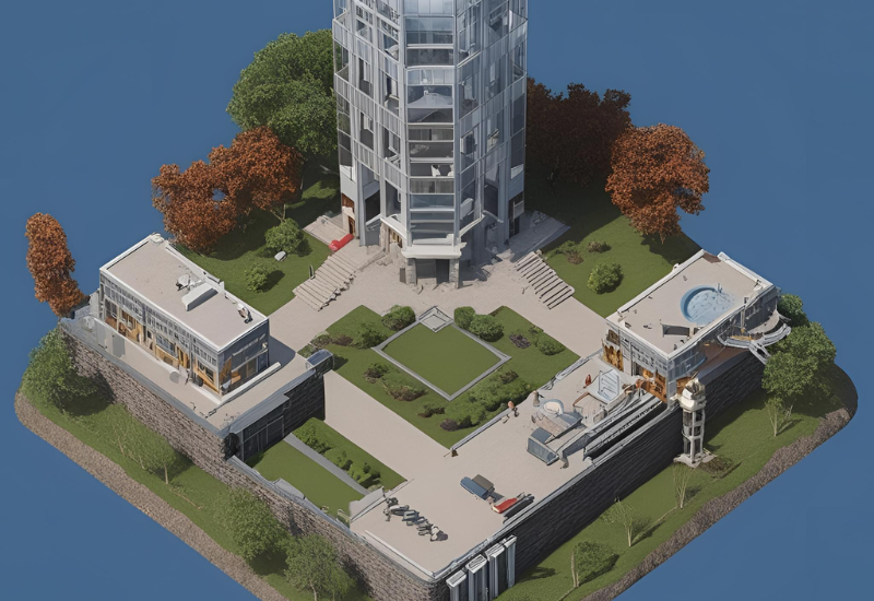
This is where Aerial 3D Rendering is revolutionizing the industry. By combining drone technology, photogrammetry, and advanced 3D visualization, aerial rendering provides a comprehensive, bird’s-eye perspective of construction sites.
This game-changing approach enhances site analysis, improves stakeholder communication, and minimizes costly errors before breaking ground. In this blog, we’ll explore how aerial 3D rendering is reshaping construction planning and why it’s becoming an essential tool for architects, engineers, and developers.
Understanding Aerial 3D Rendering
Aerial 3D rendering is a powerful tool used in architecture, real estate, and urban planning. It creates realistic, bird’s-eye views of buildings, landscapes, and entire cities using computer-generated imagery. This technology helps designers, developers, and clients visualize projects before they are built.
One of the main benefits of aerial 3D rendering is its ability to show a project in its full context. Unlike traditional 2D maps or floor plans, it gives a complete picture of how a structure fits within its surroundings. This is especially useful for large developments, such as housing communities, commercial complexes, and city planning.
Real estate developers use aerial 3D rendering to showcase properties to potential buyers. It allows them to highlight key features such as roads, parks, and nearby facilities. Architects and urban planners also rely on it to study how buildings interact with the environment, ensuring better designs.
Advancements in technology have made aerial rendering more realistic than ever. High-quality textures, accurate lighting, and detailed landscapes make these renderings look almost like real photographs. Drone photography is often combined with 3D modeling to create even more precise representations.
The Role of Aerial 3D Rendering in Construction Planning
Aerial 3D rendering plays a crucial role in modern construction planning. It provides a bird’s-eye view of a project, helping architects, engineers, and developers visualize the site before construction begins. With this technology, teams can see the entire landscape, identify challenges, and plan efficiently.
One of the biggest advantages of aerial 3D rendering is improved site analysis. It allows professionals to assess the land’s topography, spot obstacles, and design structures that fit the environment. This reduces errors and prevents costly changes later in the project.
Another benefit is better communication. Aerial 3D renderings create clear, realistic visuals that help stakeholders, including investors and clients, understand the project. These detailed images make presentations more effective and decision-making faster.
Additionally, aerial renderings support urban planning by showing how new buildings will fit into existing surroundings. City planners can analyze roads, utilities, and green spaces to ensure smooth integration.
Safety is another key advantage. Construction teams can identify hazardous areas, plan safe access routes, and reduce risks before starting work.
In summary, aerial 3D rendering enhances construction planning by offering accurate site analysis, improving communication, aiding urban development, and ensuring safety. This technology helps construction professionals plan smarter, reduce costs, and bring their visions to life with greater precision.
Key Benefits of Aerial 3D Rendering in Construction
- Aerial 3D rendering is transforming the construction industry by providing accurate, detailed, and realistic visualizations of projects before they are built. Here are some key benefits:
Higher Accuracy & Reduced Errors
- Aerial 3D rendering helps architects, engineers, and contractors get precise measurements and realistic representations of a construction site. This reduces the chances of miscalculations, design flaws, and costly rework. It also ensures that every element fits correctly within the project’s environment.
Time Savings & Faster Project Execution
- With aerial 3D rendering, teams can visualize the entire project layout before construction begins. This speeds up approvals, reduces delays, and improves collaboration among stakeholders. Contractors can plan resources efficiently, ensuring a smoother workflow and faster project completion.
Risk Mitigation & Safety Enhancements
- Construction sites can be hazardous, and aerial 3D rendering helps identify potential risks before work starts. By analyzing site conditions from a bird’s-eye view, teams can spot dangerous areas, optimize equipment placement, and improve worker safety. This reduces accidents and ensures compliance with safety regulations.
Sustainability & Environmental Impact Assessment
- Aerial 3D rendering also plays a vital role in sustainability. It allows builders to assess the environmental impact of a project, helping them make eco-friendly choices. By analyzing land usage, water drainage, and energy efficiency, companies can minimize their carbon footprint and create greener structures.
- In summary, aerial 3D rendering improves accuracy, saves time, enhances safety, and promotes sustainability, making it an essential tool for modern construction projects.
Future of Aerial 3D Rendering in Construction
Aerial 3D rendering is changing the way construction projects are planned, designed, and managed. With the help of drones and advanced 3D software, architects, engineers, and contractors can now visualize projects from a bird’s-eye view before construction even begins. This technology is expected to play an even bigger role in the future of construction.
One major advantage of aerial 3D rendering is improved site analysis. By capturing detailed images from above, professionals can study the land, identify obstacles, and plan efficiently. This reduces errors and saves both time and money.
Another important benefit is better communication. 3D aerial views help stakeholders, including clients and investors, understand a project clearly. Instead of relying on blueprints, they can see a realistic representation of the finished structure. This makes decision-making faster and more accurate.
Aerial 3D rendering will also enhance project monitoring. Construction teams can track progress in real-time by comparing current site conditions with the planned design. This helps in spotting issues early and avoiding costly mistakes.
Looking ahead, AI and machine learning will further improve aerial 3D rendering. These technologies will automate data processing, making it even easier to create precise models. Virtual and augmented reality could also be integrated, allowing professionals to explore construction sites digitally.
As technology continues to evolve, aerial 3D rendering will become a must-have tool in construction. It will lead to smarter planning, better collaboration, and more efficient building processes.
Conclusion
Aerial 3D rendering is transforming construction planning by providing accurate, immersive, and data-rich visualizations of project sites. From improving site analysis and enhancing communication to reducing risks and promoting sustainability, this technology is streamlining the way architects, engineers, and developers approach construction.
As advancements in AI, drones, and 3D visualization continue to evolve, aerial rendering will become an indispensable tool for modern construction projects. By adopting this game-changing technology, professionals can ensure more efficient planning, minimize costly errors, and bring their projects to life with greater precision and confidence.